Solar-Induced Chlorophyll Fluorescence (SIF) Background
Lila Leatherman and Bran Black
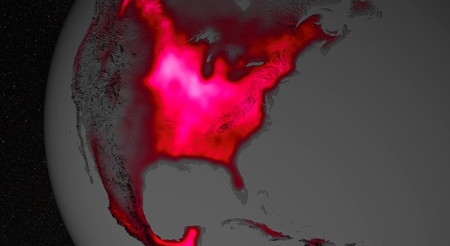
Average chlorophyll fluorescence over the Corn Belt, central US, July 2007-2011.
Overview
Motivation: Both Lila and Bran have an interest in developing tools capable of expressing change in remotely sensed data over time. The problem of displaying shifts in SIF responses over time is a good representation of both the type of input data and change detection techniques Lila and Bran plan to work with in future research, making this project an excellent case study both students may adapt for future uses.
Project Description: We have created a tool capable of displaying global SIF data for the seasonal greenup of the Northern and Southern hemispheres. A VectorField visualization has been applied to portray the spatial heterogeneity in seasonal greenup.
Seasonal greenup in the Northern Hemisphere is calculated as the mean July SIF minus the mean January SIF. Seasonal greenup in the Southern Hemisphere is calculated as the mean January SIF minus the mean July SIF. We have also added these mean monthly values as map layers.
Input Data: Solar-induced chlorophyll fluorescence (SIF) is a relatively new remote sensing index. In contrast to traditional vegetation indices (NDVI, EVI), SIF is connected to the physiology of plant production, rather than the greenness of vegetation. SIF is also more sensitive to intra-annual variation in production related to heat and drought stress. SIF is correlated with the light use efficiency of photosynthesis (LUE; Guanter et al.2014) and with absorbed photosynthetically active radiation (APAR; Rossini et al. 2010). Thus, SIF provides an ideal proxy for gross primary production (GPP) of an ecosystem. SIF is measured by the NASA GOME-2 satellite at 0.5 decimal degree spatial resolution. SIF data products cover the globe, and are provided at daily and monthly temporal resolution, from 2002-present.
Data Source: This project uses monthly SIF data from the GOME-2 satellite.
The uncertain future of carbon monitoring: The Trump administration recently defunded ongoing NASA research that would expand our capabilities to monitor SIF and other critical remote sensing indices. While these actions are still in the Congress (as of June 6, 2018), if these programs remain unfunded, we will drastically reduce our ability to monitor atmospheric carbon, and to track and predict the effects of climate change.
For more info about SIF, check out this article from NASA's Jet Propulsion Lab.
For more info about the GOME-2 satellite, check out this article from the European Space Agency.

Interface Design
Vector Field Animation: to visualize "transfer of energy"
Bootstrap Template: basic template landing page was built from
Fonts: fonts were accessed through Google font families
d3: d3.js reference for map charts
Icons: Font Awesome library